

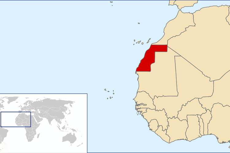
Spanish Map Separating Morocco From Western Sahara
Only four days after the Spanish institution “ENAIRE” published a map of air navigation in the Kingdom of Morocco, including the occupied Sahrawi territories, it withdrew this map from its website and published a new map of Morocco within its internationally recognized borders, that is, without extending them Including the occupied Sahrawi territories.
“ENAIRE” is a public commercial entity affiliated to the Spanish Ministry of Transport, in charge of managing air traffic in the country. It provides control and management services for routes, approaches and airports, and is responsible for air traffic control, flight information, communication networks, navigation and surveillance, Necessary for airlines to secure and regulate air navigation through Spanish airspace.
During the last four days, the Moroccan press near the Alaoui Palace in Rabat was full of articles stating that Spain had handed over the management of the airspace of the occupied Sahrawi territories to the Moroccan regime, and considered this event as a victory over the Sahrawi people and their only legitimate representative, the Polisario Front, and this came in the midst of talk of negotiations to transfer the airspace of Western Sahara to the Moroccan authorities.
The Spanish newspaper El Independiente reported that a new map issued by the navigation company ENAIRE, after it was corrected, shows borders between the internationally recognized map of the Kingdom of Morocco and the occupied Western Sahara.
The newspaper said that the Spanish air navigation company “corrected the controversial map after the information published by the newspaper “El Independent” earlier this week.
The website now contains a new version of the map showing the former Spanish colony (Western Sahara), the last colonized territory in Africa, separated from Morocco by dotted lines and clearly identified under the name Western Sahara.
To justify this discrepancy in the map, sources from the Spanish Aeronautical Authority explained that they had initially relied on “a map taken from the map base of the American company ESRI, which is a prominent technical reference in the aeronautical sector and has nothing to do with geopolitical issues”. An indication of its avoidance of entering the political debate between the Moroccan regime and the Sahrawi Republic and its repercussions on relations with Algeria.
The Spanish Maritime Corporation’s decision to revise the map, limiting Morocco to its internationally recognized borders, came after it was accused by the Polisario Front of having “contributed decisively to the strategy launched by Morocco to annex the territory of Western Sahara to its territory.
The withdrawal of the Spanish navigation company from the annexation of the airspace of the Sahara to its Moroccan counterpart, which is managed by Madrid, is a dramatic denial of the propaganda that the Moroccan press has been pouring into this matter for weeks, in a way that gave the impression that the matter was decided, when it is exactly the opposite, especially since this process requires laborious and difficult negotiations. According to Spanish reports, this process began at the beginning of March last year, despite the fact that the issue was put on the table of Moroccan King Mohammed VI during the visit of Spanish Prime Minister Pedro Sanchez to Rabat in March 2022.
The actions of the Spanish Maritime Corporation, which is attached to the Ministry of Transport, indicate that Madrid is pursuing a policy of playing both sides in its relations with Algeria and the Moroccan regime. It is aware that considering the Sahrawi territories as part of the map of Morocco in the erased map angers Algeria and the Sahrawi Republic, and returning to the situation of the border between the two countries, Morocco and Western Sahara, also angers the Moroccan regime, but it has continued this game, which is now exposed to everyone.


