

How Colonial France Had Planned To Divide Algeria
-
-
810
-
0
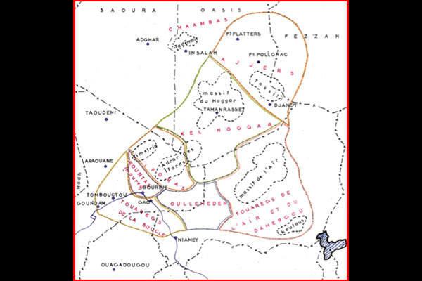
A “leaked” map concocted by the French authorities, revealed by French “Liberation” newspaper, showed how Paris has relentlessly continued over the years to stoke tension in southern Algeria.
This map shows the oil areas of southeastern Algeria as Tuareg territory in addition to an extension of Algeria to include Libya, Mali and Niger.
What is striking is that this map was prepared by the French authorities in 1962 at the time of the discussion on borders of the new Algerian state where France had planned to cut Algeria in two to keep the South in its favor with all its vast oil resources.
And as colonial France failed in its attempts, it concocted a plan to give the territory a Touareg after the independence of Algeria.
Indeed, while the war in Algeria was over, and then opened the liquidation period of colonial rule between the cease-fire of 19 March 1962 and independence on 5 July 1962, the question of the Touareg in the heart of the Sahara was more than ever present in the mind of Jacques Foccart, a close advisor to President Charles de Gaulle, then secretary general of the Elysee in charge of African and Malagasy affairs.
Since the failure of the OCRS (Common organization of the Sahara), created in 1957 to “isolate” the Sahara issue of the war in Algeria, France had sought to build a Saharan policy without ever allowing it to take shape. After the ephemeral institutional constructions (OCRS) remained the direct question of the Targui populations at the time of creation of the new regional power that is Algeria.
Since the start of the preliminary secret negotiations of 1961, the FLN secured that the Sahara issue must not be separated from that of the independence of Algeria, contrary to what originally hoped France.
In this context, Foccart launched an investigation. It resulted in the hands of one of his most loyal collaborators, Jacques Mouradian, who was the author of books on Islam in West Africa in the 1950s. Specialist of the African Muslim world and the Saharo–sahelian space he was one of the leading experts within the French administration. Then, note was forwarded to Foccart on April 11, 1962, with on focus, a map of the Tuareg populations across the Saharan borders.
Overall, as many administrators, military or French intellectuals, the note of April 11, 1962 was part of a general look at the Tuareg populations which tends to detach these nomads of state powers born of independence both in the North (Algeria) and South (Mali, Niger) with over 20% of them were in favor of the independence of Algeria.
The leak of this contentious and divisive map at a time of high tension in the sub-Saharan region and with the presence of French troops in northern Mali raises a number of outstanding questions, according to seasoned political analysts.


